Parts of Northern Luzon were placed under Signal Number 1 as Goring developed into a severe tropical storm, the state weather bureau PAGASA said on Friday afternoon.
The affected areas include the following:
- Batanes
- the eastern portion of Babuyan Islands (Babuyan Is., Camiguin Is.)
- the eastern portion of mainland Cagayan (Santa Ana, Gonzaga, Lal-Lo, Gattaran, Baggao, Peñablanca, Santa Teresita, Buguey, Camalaniugan, Aparri)
- the eastern portion of Isabela (Maconacon, Divilacan, Palanan, Dinapigue, San Mariano, San Pablo, Cabagan, Tumauini, Ilagan City)
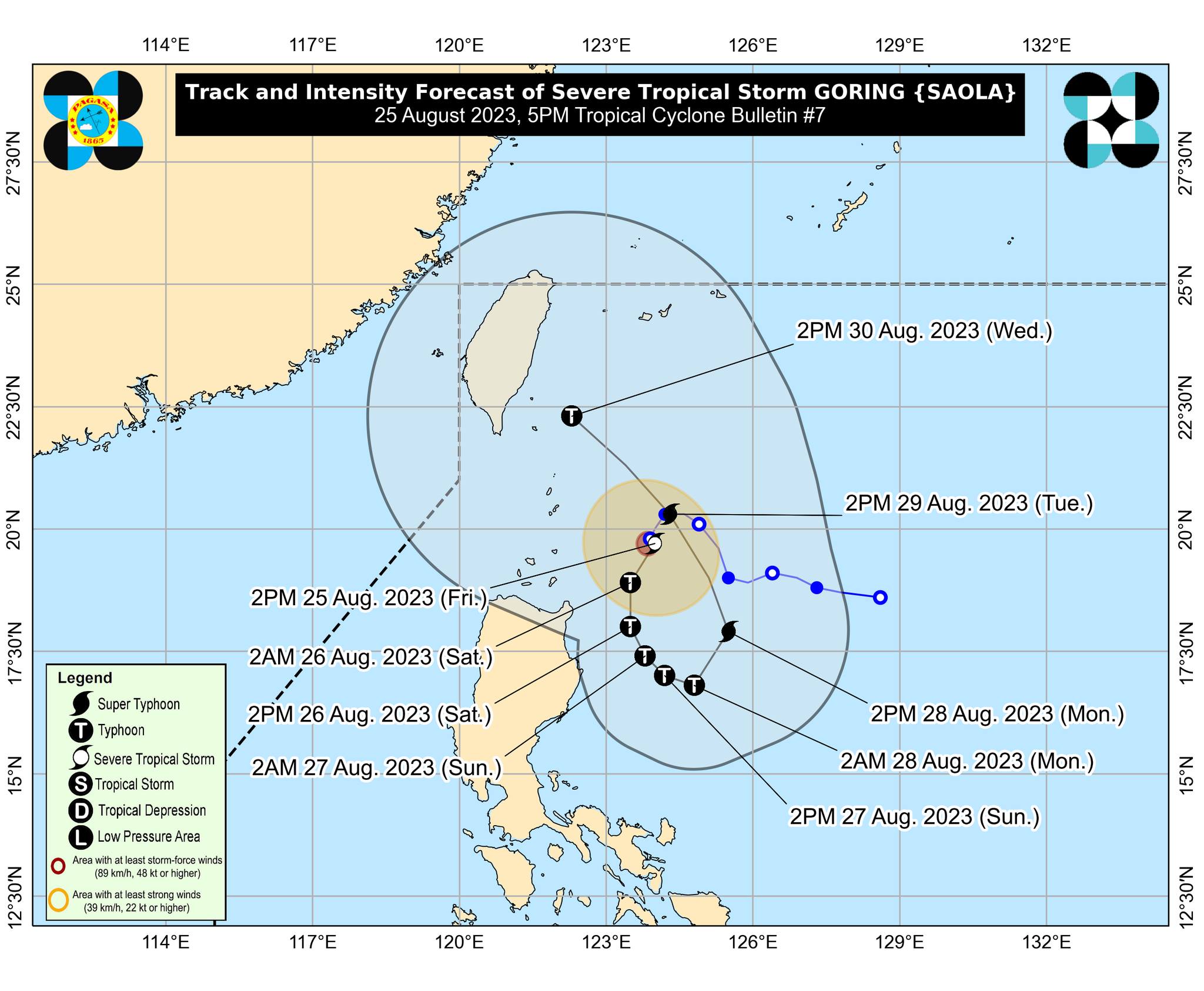
At 4 p.m., Goring was located 260 kilometers east of Calayan, Cagayan, packing maximum sustained winds of 110 kilometers per hour near the center and gustiness of up to 135 km/h, PAGASA said in its 5 p.m. bulletin.
PAGASA forecast accumulated rainfall from Friday to Saturday afternoon in the following areas:
- 50-100 mm: Batanes, Babuyan Islands, and the northeastern portion of mainland Cagayan
Saturday afternoon to Sunday afternoon
- 100-200 mm: Eastern portions of mainland Cagayan, Isabela, and the northern portion of Aurora
- 50-100 mm: Babuyan Islands and Ilocos Provinces and the rest of mainland Cagayan and Isabela
Sunday afternoon to Monday afternoon
- 50-100 mm: Ilocos Provinces, northern portion of Aurora, and the eastern portions of Cagayan and Isabela
Meanwhile, the enhanced Southwest Monsoon (Habagat) will bring occasional rains over the western portions of Central Luzon and Southern Luzon beginning Saturday and over the western portion of Visayas starting on Sunday.
PAGASA said a coastal gale warning is in effect over the northern and eastern coastal waters of Northern Luzon and the eastern coastal waters of Central Luzon due to strong winds associated with Goring, which may cause sea travel to be risky for certain types or tonnages of vessels.
”Disruption in civilian maritime activities is expected in these areas,” it added.
Goring is expected to move south southwestward or southward over the waters east of Northern Luzon until Saturday evening, then turn generally south or southeastward for the rest of Saturday through Sunday afternoon.
The tropical cyclone will then loop northward before turning to the northwest on Tuesday towards Luzon Strait.
”Due to a highly favorable environment, Goring is forecast to rapidly intensify and may reach typhoon category by tomorrow. Goring is forecast to steadily strengthen and may attain its maximum strength by Monday, potentially becoming a super typhoon,” PAGASA said.