THE oil spill from the sinking of the MT Princess Empress in Oriental Mindoro may reach Palawan and could affect 36,000 hectares of coral reefs, mangroves, and seagrass, according to the Marine Science Institute of the University of the Philippines.
The marine experts warned coastal communities in Oriental Mindoro, Caluya Island in Antique, and Cuyo Island in Palawan to prepare for the possibility that the oil spill could reach their shores.
It could damage marine resources and affect people’s sources of food and livelihood, the UP MSI said.
“Aside from the ecological damage to these habitats, damage from the oil slick will also have an economic impact on livelihood and food sources. The public is encouraged to report any sighting of oil slick to authorities and adhere to public guidance to prevent its harmful effects,” it said in a March 4 bulletin.
The MT Princess Empress was carrying 800,000 liters of fuel when it encountered engine trouble and sank amid rough seas on February 28. Its crew members were rescued.
Marine life at risk
The UP MSI said in another bulletin that it based its latest estimates of the affected marine resources on the modeled oil spill trajectories and the higher resolution data it was able to obtain.
It said approximately 20,000 hectares of coral reefs, 9,900 hectares of mangroves, and 6,000 hectares of seagrass in 21 municipalities in Oriental Mindoro, Occidental Mindoro, Antique, and Palawan may be at risk from the oil slick.
More than half, or 11,000 hectares, of the potentially affected reefs are found in the Cuyo group of islands, which is northeast of Palawan.
The areas at risk also include several marine protected areas, such as the reefs in Bulalacao, Oriental Mindoro. There are also significant sea grass beds in several areas, including Pola, Mansalay, and Bulalacao in Oriental Mindoro, it said.

Philippine bishops instruct flock to pray for rain, heat relief
Catholic bishops in the Philippines are pitching in to seek.

ALAMIN: Paraan kung paano palaguin ang ipon
KADALASAN, kapag tayo ay nagtatabi ng pera, sa alkansya o.

Cedric Lee pasok na sa Munti
INILIPAT na sa Bureau of Corrections (BuCor) sa Muntinlupa City.
Caluya Island in Northwestern Antique likewise has significant areas of coral reefs, mangroves, and seagrass meadows, it said.

Areas that may be affected by the oil slick from the MT Princess Empress | Photo from UP MSI
The potentially affected areas are twice the size of Quezon City, Metro Manila’s largest city. Quezon City has a land area of over 16,000 hectares.
The UP MSI initially said 24,000 hectares of coral reefs were at risk. But it later said this was an “overestimation” based on preliminary coarse resolution data and has since amended it.
Oil slick trajectories
UP MSI oceanographer Dr. Cesar Villanoy and his team developed an oil spill trajectory model to forecast the track and the transport of the slick from March 3 to 7, based on prevailing weather patterns and conditions. This is intended to help communities and agencies to prepare.
The team came up with three trajectory runs.
The first scenario considers the possibility of the oil slick heading northwards towards the Verde Island Passage, the center of global shore-fish biodiversity. If this happens, Calapan and Puerto Galera could be affected.
The second scenario considers the continuous release of oil from the alleged seepage location, and in this case, most of the slick will end up in Pola Bay.
The third scenario considers the continuous release of oil from the suspected seepage location, but with the latest information on the slick factored in. In this model, the oil slick is shown moving southwards. It has now been confirmed to have reached the coasts of Pinamalayan and Bongabong.
The model also shows that some of the slick may pass through Caluya Island in Northwestern Antique and could eventually reach Cuyo Island.
“The model however, again, only shows potential trajectories in the next four days,” the UP MSI said.
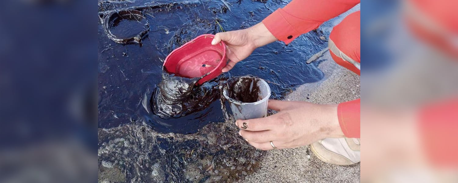
How big is the oil slick?
Based on aerial surveys by the UP MSI and the Department of Environment and Natural Resources conducted on March 3, the slick is estimated to be around 25 kilometers long and 300 to 500 meters wide.
It is roughly oriented northeast to southwest, with its tail end situated in Pola Bay.
Actions taken
Marine experts from the UP and Mindanao State University-Iligan Institute of Technology are working with the DENR and the Philippine Coast Guard to address the effects of the spread of oil from the tanker.
PCG spokesperson Rear Admiral Armand Balilo said the MT Princess Empress contained industrial fuel oil, which could harm the marine environment and affect the ecosystem.
It could also make people sick as the oil could harm their lungs and skin, Balilo said.
Balilo said the PCG has sent personnel for oil spill recovery operations. It has also been coordinating with other stakeholders to seek their help.
The tanker’s owner, RDC Reield Marine Services Inc., has deployed tugboats to put up oil spill booms to prevent the further spread of the oil.
But Balilo said the operation is facing challenges because of the weather and the big waves in the area.
This was also why he could not say how long the clean up operations would last.