A LOW pressure area (LPA) has formed inside the Philippine Area of Responsibility, and the rainclouds outside its band will dampen Mindanao, as well as Eastern and Central Visayas regions today, February 16.
Flood alert is still up in Caraga and Davao regions.
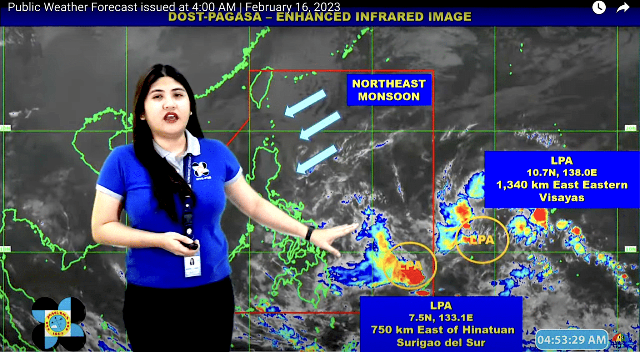
Meanwhile, the Northeast Monsoon or amihan in Filipino, continues to get stronger. Cagayan Valley, Cordillera Administrative Region, Aurora, Quezon, Oriental Mindoro, and Bicol Region will be rainy today, too.
So bring your umbrellas, and continue monitoring the weather for possible flooding.
2 LPAs
State weather bureau Pagasa said based on their satellite monitoring as of 3 am, the LPA is located 750 kilometers east of Hinatuan in Surigao del Sur.
Another LPA was monitored outside the PAR — approximately 1,340 kilometers east of the Visayas archipelago.
“Ang dalawang LPA — mababa ang tsansa na maging bagyo sa araw na ito. Pero di natin inaalis ang posibility na ito’y maging bagyo sa mga susunod na araw,” Pagasa weather forecaster said Veronica Torres.
Rainy Visayas, Mindanao
The trough of the LPA in Surigao will bring moderate to heavy rains over Davao region, Caraga and Eastern Visayas.
Light to moderate with at times heavy rains are expected over Central Visayas and the rest of Mindanao.
“Under these conditions, flooding and rain-induced landslides are possible, especially in areas that are highly or very susceptible to these hazards,” Pagasa warned.
Rainy in Cagayan, Cordilleras, south Luzon
It will be cloudy and rainy as well in Cagayan Valley, Cordillera Administrative Region, Aurora, Quezon, Oriental Mindoro and Bicol Region.
Metro Manila and the rest of Luzon meanwhile will be generally fair.
Torres said the Northeast Monsoon is affecting Luzon as well as some parts of Visayas.
Gale warning
Bad news for fisherfolks or banca boatsmen who only have small seacrafts for a living — Pagasa has issued gale warning again.
Winds brought by the Northeast Monsoon have become stronger and could trigger waves as high as 5.5 meters or 18 feet, which is equivalent to a two story-building.
The gale warning is up over the following areas:
- western seaboard of Northern Luzon
- Ilocos Norte, Ilocos Sur, La Union, Pangasinan
- north and eastern seaboard of Luzon and the western seaboard of Visayas
- Batanes, Cagayan Including Babuyan Islands, Isabela, Aurora, The Eastern Coast Of Quezon Including Polillo And Alabat Islands, Camarines Norte, The Northern Coast Of Camarines Sur, The Northern And Eastern Coasts Of Catanduanes, The Eastern Coast Of Albay, The Eastern Coast Of Sorsogon, The Northern And Eastern Coasts Of Northern Samar, Eastern Samar, The Eastern Coast Of Southern Leyte, Dinagat Islands, Siargao Island
- west and south seaboards of Luzon and western seaboard of Visayas
- Zambales, Bataan, Batangas, The Southern Coast Of Quezon, The Northern Coast Of Occidental Mindoro Including Lubang Island, Oriental Mindoro, Marinduque, Romblon, And Antique [caluya])
Weather at a glance
| Place | Weather Condition | Caused By | Impacts |
| Caraga, Davao Region, Northern Mindanao, and Zamboanga Peninsula | Cloudy skies with scattered rainshowers and thunderstorms | Trough of LPA | Possible flash floods or landslides due to moderate to heavy rains |
| The rest of Mindanao | Partly cloudy to cloudy skies with isolated rainshowers or thunderstorms | Trough of LPA / Localized Thunderstorms | Possible flash floods or landslides during severe thunderstorms |
| Cagayan Valley, Cordillera Administrative Region, Aurora, Quezon, Oriental Mindoro, and Bicol Region | Cloudy skies with rains | Northeast Monsoon | Possible flash floods or landslides due to moderate to heavy rains |
| Metro Manila, the rest of Luzon, and Visayas | Partly cloudy to at times cloudy skies with light rains | Northeast Monsoon | No significant impact |