IT’S still umbrella and raincoat weather in most parts of the country today.
A new low pressure area has entered the Philippine area of responsibility and is expected to bring rains in Palawan, Visayas, and Mindanao, according to the state weather bureau.
The northeast monsoon, on the other hand, will bring rains in most of Luzon.
Some parts of the country are warned against possible floods and landslides.
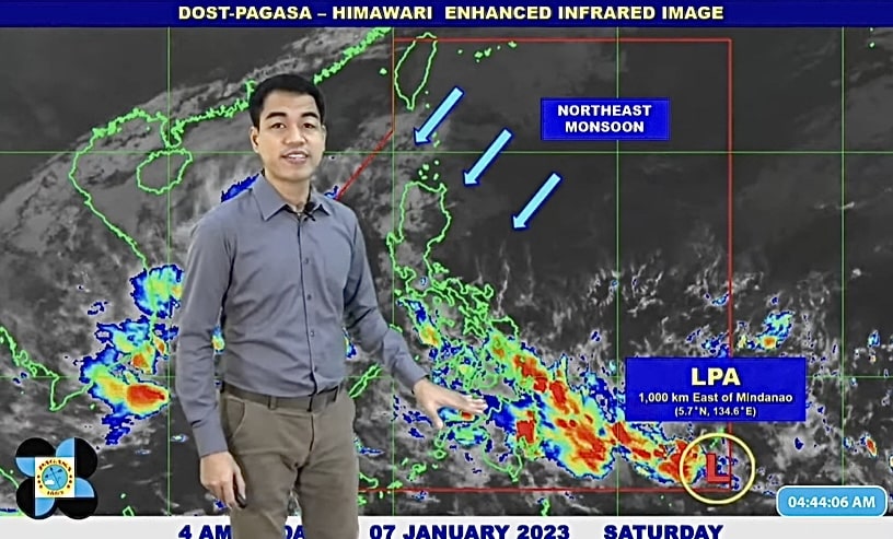
LPA track
The low pressure area entered the country this morning and as of 3 a.m., it was spotted east of Southeastern Mindanao.
There is a low chance of the LPA strengthening into a tropical depression this weekend, according to weather specialist Benison Estareja.
Estareja also said the LPA is expected to leave the Philippine area of responsibility in the next day or two, but is forecast to return to country by Monday or Tuesday.
But regardless of whether it is in or outside the Philippines, it will bring rains in Visayas and Mindanao up to next week, he said.
LPA effects
Palawan and most of Visayas and Mindanao will have cloudy skies with scattered rain showers or thunderstorms due to the trough or extension of the LPA.
The rains will be heaviest in Eastern and Central Visayas, Northern Mindanao, Caraga region, and Davao region.
Residents in these areas are advised to take caution as flooding and landslides are possible due to moderate to heavy with at times intense rains.
The rest of Visayas and Mindanao will have light to moderate with at times heavy rains.
Northeast monsoon
The rest of Luzon can expect to feel the cold winds from the northeast monsoon.
It will bring light to moderate rains in Cagayan Valley, Cordillera Administrative Region, the rest of Mimaropa, the Bicol region, Aurora, and Quezon.
Flash floods and landslides are possible due to moderate with at times heavy rains in these areas.
Metro Manila and the rest of Luzon will have partly cloudy to cloudy skies with light rains.
Gale warning
The northeast monsoon continues to cause rough to very rough seas from Luzon to the Caraga region.
Waves may reach as high as 5 meters, equivalent to a two-storey building, in Luzon, and as high as 4.5 meters in other areas.
These are the affected areas:
- Ilocos Norte
- Batanes
- Cagayan
- Isabela
- Aurora
- Northern Quezon including Polilio Islands
- Camarines Norte
- Northern coast of Camarines Sur
- Catanduanes
- Eastern coast of Albay
- Eastern coast of Sorsogon
- Northern Samar
- Eastern Samar
- Eastern coast of Southern Leyte
- Dinagat Islands
- Eastern coast of Surigao del Norte
The sea conditions are dangerous for fishing boats and small sea craft, and these areas are advised not to venture out into the sea. Larger vessels are alerted against big waves.
Temperature check
The mercury continues to be lower in parts of Luzon which is feeling the cold winds from the northeast monsoon.
Baguio temperature today will range from 15 to 21 degrees Celsius, while in Tagaytay it will be from 20 to 28 degrees Celsius.
In Metro Manila, the temperature will range from 23 to 29 degrees Celsius.
The temperature in Laoag will be from 24 to 31 degrees Celsius, and in Tuguegarao 22 to 26 degrees Celsius.
In Legazpi, the temperature will be from 24 to 28 degrees Celsius, in Puerto Princesa 26 to 31 degrees Celsius, and Kalayaan Isands 26 to 30 degrees Celsius.
In Cebu, the temperature will range from 25 to 30 degrees Celsius, in Tacloban 24 to 30 degrees Celsius, and Iloilo 25 to 30 degrees Celsius.
The temperature in Davao will range from 24 to 30 degrees Celsius, Cagayan de Oro 25 to 28 degrees Celsius, and Zamboanga 24 to 31 degrees Celsius.
Visayas forecast
Ang tibook Visayas, southern half sa Palawan apil na ang Kalayaan Islands makasinati ug madag-umon na kalangitan inubanan sa mga katag-katag na mga pag-ulan, pagpangilat ug pagpanugdog tungod sa Trough sa LPA / Shear Line. Ang nahibiling bahin sa Palawan, ug ang Occidental Mindoro makasinati ug mapanganuron nga kalangitan inubanan sa pag-ulan tungod sa Amihan.
Kasarangan ngadto na sa kusog na hangin nga gikan sa Amihanang-sidlakan ngadto na sa Silangan ang mupasulabi sa tibook Visayas, Palawan lakip na ang Kalayaan Islands, ug sa Occidental Mindoro diin ang kadagatan adunay kasarangan ngadto na sa baluron ang kahimtang.
Mindanao forecast
Ang tibuok dapit sa Mindanao makasinati sa mapanganuron nga kalangitan inubanan sa katag katag nga pag ulan, kilat ug panalugdog tungod sa Trough of LPA / Shear Line. Possible ang flooding o landslides tungod sa kasarangan ngadto na sa usahay kusog nga pag-ulan. Kasarangan ngadto na sa kusog nga hangin ang magagikan sa amihanang silangan ngadto na sa silangang direksyon ug ang kadagatan kasarangan ngadto na sa kusog ang pagbalud (1.2 to 4.5 meters).