
IF you are going out for a family outing or Sunday mass in Eastern Visayas, Caraga and Davao Oriental, it may be a good idea to bring a raincoat, umbrella, and all-weather boots.
Pagasa, the state weather forecasting agency, said rainclouds formed along the shear line are dragging more rain to the mid-eastern section of the country.
The shear line is a narrow corridor of where cold and hot winds converge.
Aside from moderate rains, Eastern Visayas, Caraga, and Davao Oriental may have thunderstorms, too. Moderate to heavy rainfall may trigger landslides or flooding.
Pagasa warned of “severe” flooding in low-lying areas as the water level in the rivers and tributaries have reached critical level:
- Eastern Samar
- Northern Samar
- Samar
- Leyte
- Southern Leyte
- Biliran
- Dinagat Islands
- Agusan del Norte
- Agusan del Sur
- Surigao del Norte
- Surigao del Sur
- Davao Oriental
Northeast Monsoon
The Northeast Monsoon is getting stronger and will likely bring rains to the eastern portion of Luzon.
It will be generally cloudy but there may be light to moderate rains here or there in the following areas:
- Cordillera Administrative Region
- Cagayan Valley
- Bicol Region
- Aurora
- Quezon
- Marinduque
- Romblon
- Oriental Mindoro
Metro Manila and the rest of Luzon will be fair.
Localized thunderstorms
There is no Low-Pressure Area monitored inside the Philippine Area of Responsibility.
Grace Castañeda, a weather specialist, said Pagasa is monitoring a cluster of clouds southeast of Mindanao which may form into an LPA.
There may be sudden downpours of rain in other parts of Visayas and Mindanao today. It is due to localized thunderstorms.
Temperature Check
Due to the Northeast Monsoon, the temperature in northern Luzon will continue to drop today.
Baguio City residents and tourists need warmer jackets today, as they will likely experience 12°C temp. Mercury in Baguio dipped to 14°C yesterday at 4:50 am.
But it was Basco, Batanes, and not Baguio City – which felt the most chill morning yesterday. Around 2 am, Basco residents probably had to add a layer of blankets and jackets and snuggled into bed at 13.8°C.
Other areas with below 20°C temp yesterday morning:
- Calayan, Cagayan – 17.2°C
- Tanay, Rizal – 18.8°C
- Malaybalay, Bukidnon – 19.2°C
- Tuguegarao, Cagayan – 19.5°C
- Aparri, Cagayan – 19.6°C
LUZON TEMPERATURE TODAY
- Baguio: 12-22°C
- Tuguegarao: 17-24°C
- Tagaytay: 18-27°C
- Laoag: 20-28°C
- Metro Manila: 22-29°C
- Legazpi: 23-27°C
- Puerto Princesa: 25-30°C
- Kalayaan Islands: 25-30°C
VISAYAS AND MINDANAO TEMPERATURE TODAY
- Iloilo: 23-28°C
- Tacloban: 23-28°C
- Cebu: 24-29°C
- Cagayan de Oro: 24-28°C
- Davao: 25-31°C
- Zamboanga: 24-32°C
Gale warning
Amihan continues to bring strong gale force winds to the entire eastern and western seaboard of Luzon, eastern Visayas, and northeast of Mindanao. Waves could reach as high as 5.5 meters or more than a one-story building.
So fishermen or operators of small seacrafts are advised against going out to open sea in the following areas:

- Batanes
- Cagayan Including Babuyan Islands
- Isabela
- Aurora
- Quezon Including Polillo Islands
- Oriental Mindoro
- Marinduque
- Romblon
- Camarines Norte
- Camarines Sur
- Catanduanes
- the eastern coast of Albay
- the eastern coast of Sorsogon, Burias Island
- I
- Northern and eastern coasts of Northern Samar
- Eastern coast of Eastern Samar
- Eastern Coast Of Dinagat Islands
- the Eastern Coasts Of Siargao and Bucas Grande Islands

- locos Norte
- Ilocos Sur
- La Union
- Pangasinan
- Zambales
- Bataan
- Cavite
- Batangas
- Occidental Mindoro Including Lubang Island
- Palawan including Cuyo and Kalayaan Islands
- Western seaboard of Antique
Weather at a Glance
| PLACE | WEATHER CONDITION | CAUSED BY | IMPACTS |
| Eastern Visayas, Caraga, and Davao Oriental | Cloudy skies with scattered rainshowers and thunderstorms | Shear Line | Possible flash floods or landslides due to moderate to at times heavy rains |
| Cagayan Valley, Cordillera Administrative Region, Bicol Region, Aurora, Quezon, Oriental Mindoro, Marinduque, and Romblon | Cloudy skies with rains | Northeast Monsoon | Possible floods or landslides due to moderate with at times heavy rains |
| Metro Manila and the rest of Luzon | Partly cloudy to cloudy skies with light rains | Northeast Monsoon | No significant impact |
| The rest of the country | Partly cloudy to cloudy skies with isolated rainshowers or thunderstorms | Localized Thunderstorms | Possible flash floods or landslides during severe thunderstorms |
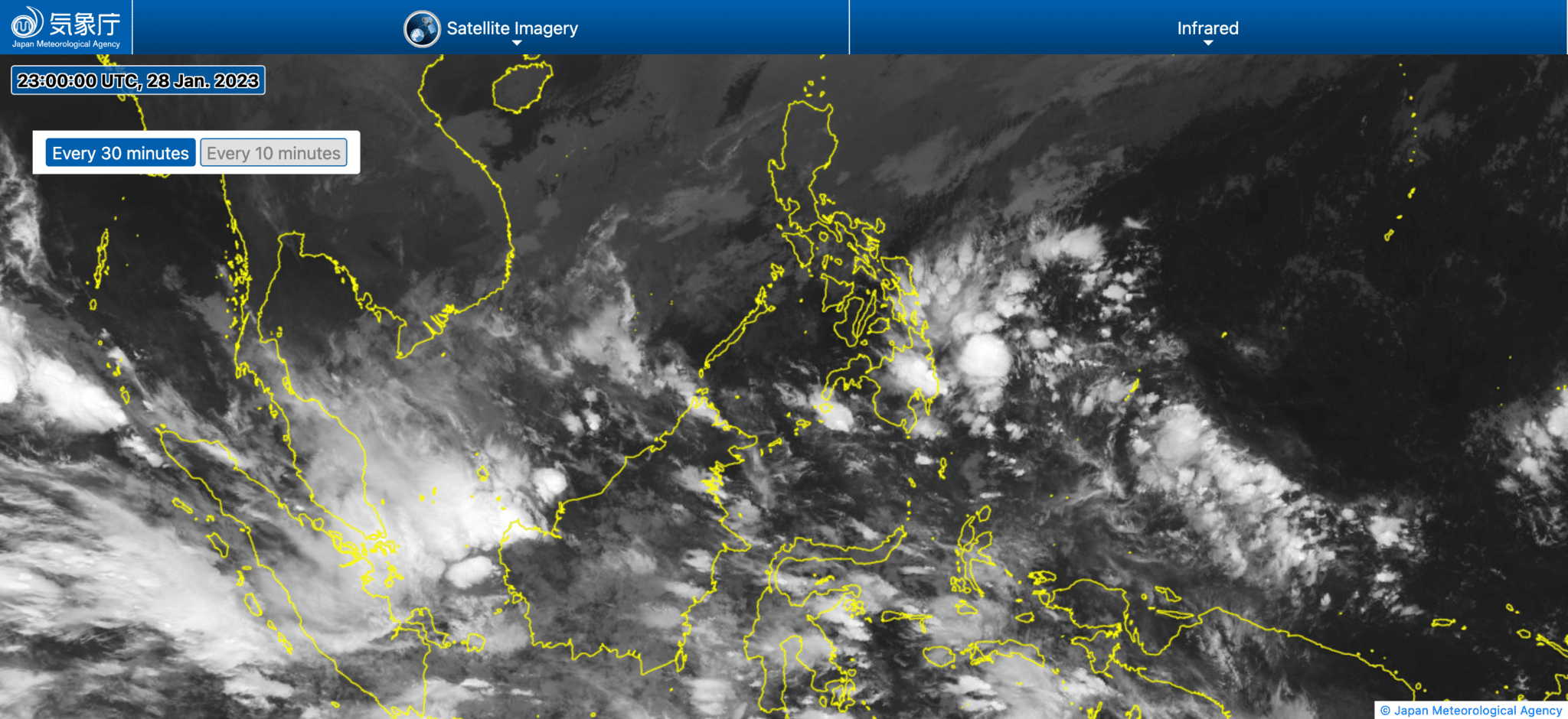
Banner photo: Satellite image of Philippines Courtesy Japan Meteorological Agency