
The cool breeze and December solstice may lull you to sleep. Bed weather. But wake up! It’s still Wednesday, a wins-day, a hump-day. Hindi ka pa mayaman! And don’t forget your umbrellas!
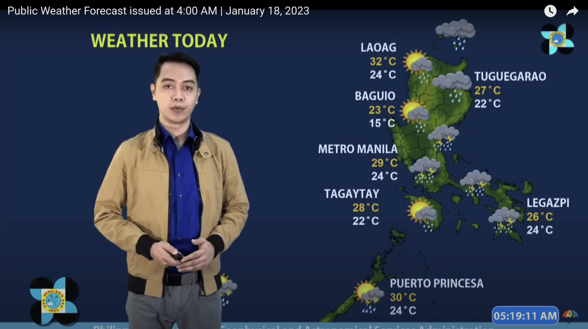
Pagasa weather forecast on January 18, 2022 is that there’s gonna be moderate to heavy rainfall in the following areas:
- Metro Manila
- Calabarzon
- Bicol region
- Nueva Ecija
- Bulacan
- Aurora
- Quezon
- Apayao
- Cagayan Valley
Camarines Norte classes are still suspended today.
Governor Ricarte ‘Dong’ Padilla
Flooding or landslides induced by rains may occur in those areas.
Windy.com, a Czech-based website aggregator of climate data, also predicts moderate rains over north Palawan and eastern section of Mindoro Oriental in the afternoon.
Pagasa said the rest of Luzon will have party cloudy skies with a bit of light rains.
Visayas and Mindanao will be cloudy, but can get wet and experience severe thunderstorms.
Windy.com said North Cotabato and South Cotabato might get heavy rainfall ( between 15mm-17.6mm) with thunderstorms around 2pm.
Flood alerts
A red flood alert was raised in the Bicol region, particularly in Albay, Camarines Sur, Sorsogon, Catanduanes and Camarines Norte. Red means the treat of flooding is “extreme,” as the rivers and tributaries have overflowed from the rains for the past few days.
+ Albay – Rivers and its tributaries particularly Guinale and Upper Donsol.
+ Camarines Sur – Rivers and its tributaries particularly Lower Kilbay Catabangan, Ragay, Tinalmud, Tambang and Lagonoy.
+ Sorsogon – Rivers and its tributaries particularly Lower Donsol, Ogod, Putiao, Cadacan, Banuang-Daan, Fabrica (Tugbugan) and Matnog.
+ Catanduanes – Rivers and its tributaries particularly Cabuyan, Bato and Pajo.
+ Camarines Norte – Rivers and its tributaries particularly Labo and Daet Basud.
An orange flood alert is also up in Quezon and Rizal provinces. Orange means the threat of flooding is “severe.”
+ Quezon – Rivers and its tributaries particularly Upper Umiray, Lower Bolbok (Lawaya), Malaking-Ilog, Iyam, Macalelon, Catanauan, Silongin Lagda, Pagsanjan, Yabahaan, Bigol, Guinhalinan, Vinas, Calauag, Pandanan, Sta. Lucia, Lugan Malaybalay, Maapon, Bucal (Lalangan), Lakayat, Tignoan, Agos, Anibawan (Polilio Island) and Upper Kilbay – Catabangan.
+ Rizal – Rivers and its tributaries particularly Upper Marikina and Kaliwa.
What’s driving the rains?
There are two weather disturbances in the country today — the prevailing Northeast Monsoon in Luzon, and the Shearline.
The prevailing weather condition is the Shearline or the thin horizontal layer of clouds where the cold winds and warm winds merged. The Shearline is causing the rains in the Bicol region, Metro Manila, CALABARZON, Nueva Ecija, Bulacan, and Aurora.
Meanwhile, the persistent Northeast Monsoon north of Luzon is bringing rains over Apayao and Cagayan Valley.
It seems that the two LPA that Pagasa has been monitoring has dissipated. Pagasa’s weather advisory Tuesday 11pm still saw the LPA over the coastal waters off Silago, Southern Leyte. The other LPA was last seen 385 kilometers west off Puerto Princesa City in Palawan. However, the 4am Pagasa weather forecast no longer mentioned the two LPA’s.
Temperature check
Baguio City hit its lowest range at 15.2°C yesterday around 4:50 am. Basco, Batanes was also a bit cold at 17.7°C around 2 am yesterday.
Those living in higher planes of Tanay, Rizal and Malaybalay, Bukidnon got 19°C level.
Tuguegarao City and Calayan in Cagayan, Abucay in Bataan, Tayabas in Quezon all registered 21°C temps. Sinait in Ilocos Sur and Aparri in Cagayan also needed thicker blankets as well as mercury hit 22°C two to three hours past midnight yesterday.
However, in the case of Sinait, Ilocos Sur, the mercury swing to 32°C around 2pm yesterday. Laoag City also experienced a high of 32°C yesterday afternoon.
Luzon is experiencing above-average cold weather recently due to the effects of the Northeast Monsoon.
Despite the cool weather north of Luzon, there are still provinces getting very hot temperature yesterday. The hottest were in San Jose, Occidental Mindoro at 33.5°C and Zamboanga City at 32.7°C.
Weather at a glance
| Place | Weather Condition | Caused By | Impacts |
|---|---|---|---|
| Metro Manila, CALABARZON, Bicol Region, Nueva Ecija, Bulacan, and Aurora | Cloudy skies with scattered rainshowers and thunderstorms | Shear Line | Possible flooding or landslides due to moderate to heavy rains |
| Apayao and Cagayan Valley | Cloudy skies with rains | Northeast Monsoon | Possible flooding or landslides due to moderate to at times heavy rains |
| The rest of Luzon | Partly cloudy to cloudy skies with light rains | Northeast Monsoon | No Significant impact |
| The rest of the country | Partly cloudy to cloudy skies with isolated rainshowers or thunderstorms | Localized Thunderstorms | Possible flash floods or landslides during severe thunderstorms |
Forecast Wind and Coastal Water Condition
| Place | Speed | Direction | Coastal Water |
|---|---|---|---|
| Northern Luzon and the eastern sections of Central and Southern Luzon | Strong | Northeast | Rough / (2.8 to 4.0 meters) |
| The rest of Luzon and Visayas | Moderate to Strong | Northeast to East | Moderate to Rough / (1.2 to 2.8 meters) |
| Mindanao | Slight to Moderate | Northeast to North | Light to Moderate / (0.6 to 2.5 meters) |
How useful was this post?
Click on a star to rate it!
Average rating 0 / 5. Vote count: 0
No votes so far! Be the first to rate this post.
We are sorry that this post was not useful for you!
Let us improve this post!
Tell us how we can improve this post?