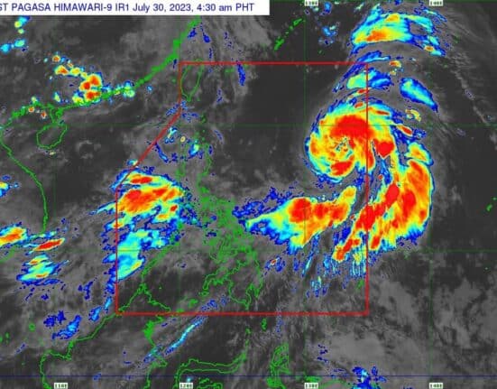
Tropical Storm Falcon intensified further early Sunday morning and continued to enhance the Southwest Monsoon (Habagat), affecting parts of Luzon and Visayas, the state weather bureau PAGASA said.
Falcon, now a severe tropical storm, carries maximum sustained winds of 95 kilometers per hour near the center and gustiness of up to 115 km/h.
At 4 a.m., Falcon’s center was spotted 1,190 km east of Northern Luzon, moving north northwestward at 15 km/h.
“The hoisting of Wind Signal due to Falcon over any locality in the country remains unlikely based on the current forecast scenario,” PAGASA said in its 5 a.m. tropical cyclone bulletin.
However, the enhanced Southwest Monsoon will bring gusty conditions over the following areas:
Sunday: Zambales, Bataan, Pampanga, Bulacan, Metro Manila, Occidental Mindoro, Palawan, Romblon, Northern Samar, and most of CALABARZON, Bicol Region and Western Visayas.
Monday: Ilocos Norte, Pangasinan, Zambales, Bataan, Pampanga, Bulacan, Metro Manila, Occidental Mindoro, Palawan, Romblon, Northern Samar, and most of CALABARZON, Bicol Region and Western Visayas.
Tuesday: Ilocos Region, Abra, Benguet, Zambales, Bataan, Bulacan, Metro Manila, Bicol Region, and most of CALABARZON, MIMAROPA, and Western Visayas
A gale warning is in effect over several coastal waters along the western seaboard of Luzon, making it dangerous for small seacraft to navigate.
PAGASA said Falcon is forecast to become a typhoon between late Sunday evening and early Monday morning and reach its peak intensity on Tuesday.
Falcon is expected to leave the Philippine Area of Responsibility on Monday evening or early Tuesday morning.
How useful was this post?
Click on a star to rate it!
Average rating 0 / 5. Vote count: 0
No votes so far! Be the first to rate this post.
We are sorry that this post was not useful for you!
Let us improve this post!
Tell us how we can improve this post?


