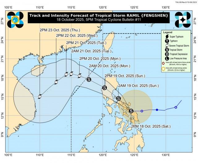

Egay is now a super typhoon, state forecasters said Tuesday morning.
According to the 7 a.m. track of PAGASA, the eye or the center of the typhoon was estimated at 310 km east of Tuguegarao City, Cagayan.
It is coming in at 185 km/h, with gusts of up to 230 kp/h, and is expected to move northwestward and cross the Luzon Strait.
State forecasters warned that the typhoon is generating strong to typhoon-force winds with an extension outwards of up to 680 km from the center.
It is moving northwestward at 10 km/h.
“Current forecast scenario shows that the highest wind signal that may be hoisted will be Wind Signal No. 4 or 5 ,” PAGASA said.
Egay may make landfall or pass very close to Babuyan Islands-northeastern mainland Cagayan area late evening Tuesday and Wednesday afternoon.
“Slight northward or southward shift in this segment of the track may result in a landfall or close approach over northern mainland Cagayan or Batanes,” PAGASA noted.
The typhoon is expected to weaken after passing over the Babuyan Islands due to the potential onset of eyewall replacement cycle as well as the interaction that will occur at the rugged terrain of Northern Luzon.
From thereon, Egay is projected to make a turn northwestward or north northwestward and will pass over the waters south of Taiwan.
It is forecast to exit the Philippine Area of Responsibility on Thursday morning.
It will reach the vicinity of Fujian, China on Friday morning.
Storm Signal No. 3 is now hoisted in the following areas: Babuyan Islands, the northern and eastern portions of mainland Cagayan (Santa Ana, Gonzaga, Peñablanca, Gattaran, Lal-Lo, Alcala, Santa Teresita, Buguey, Aparri, Camalaniugan, Ballesteros, Allacapan, Abulug, Claveria, Pamplona, Sanchez-Mira, Santa Praxedes, Lasam, Baggao, Amulung, Iguig), the northeastern portion of Isabela (Divilacan, Maconacon, Palanan), and the northern portion of Apayao (Calanasan, Luna, Santa Marcela, Flora, Pudtol)
Meanwhile Storm Signal No. 2 is up in Batanes, the rest of mainland Cagayan, the rest of Isabela, Quirino, the northern portion of Nueva Vizcaya (Kasibu, Quezon, Diadi, Bagabag, Ambaguio, Villaverde, Solano, Bayombong), the rest of Apayao, Kalinga, Abra, Mountain Province, Ifugao, the northern portion of Benguet (Bakun, Mankayan, Buguias, Kabayan, Kibungan), Ilocos Norte, Ilocos Sur, and the northern and central portion of Aurora (Dilasag, Casiguran, Dinalungan, Dipaculao)
Metro Manila, including La Union, Pangasinan, the rest of Benguet, the rest of Nueva Vizcaya, the rest of Aurora, Zambales, Bataan, Nueva Ecija, Tarlac, Pampanga, Bulacan, Metro Manila, Rizal, Laguna, Cavite, Batangas, Quezon, Marinduque, Camarines Norte, Camarines Sur, Catanduanes, Albay, Sorsogon, and the northern portion of Masbate (Uson, Dimasalang, City of Masbate, Mobo, Palanas, Aroroy, Baleno) including Burias and Ticao Islands in Luzon are all under Storm Signal No. 1.
The same goes for Northern Samar, the northern portion of Samar (San Jose de Buan, Matuguinao, Gandara, Santa Margarita, Calbayog City), and the northern portion of Eastern Samar (Oras, Arteche, Jipapad, Dolores, San Policarpo, Maslog).
PAGASA also warned os possible storm surges “which may cause flooding in the low-lying and exposed coastal areas of Batanes, Cagayan including Babuyan Islands, Isabela, and Ilocos Norte.”
How useful was this post?
Click on a star to rate it!
Average rating 0 / 5. Vote count: 0
No votes so far! Be the first to rate this post.
We are sorry that this post was not useful for you!
Let us improve this post!
Tell us how we can improve this post?