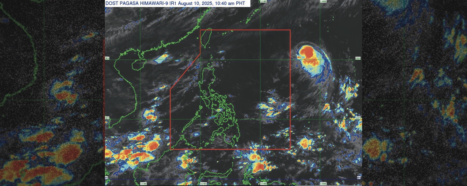

THE Philippine Atmospheric, Geophysical, and Astronomical Services Administration (PAGASA) said that a severe tropical storm, internationally known as “Podul,” is expected to enter the Philippine area of responsibility (PAR) between Sunday night, August 10, and early Monday, August 11.
The state weather bureau said Podul continues to accelerate and maintain its strength, as of 11 a.m. on Sunday.
Its center was last monitored 1,680 kilometers east of extreme Northern Luzon, with maximum sustained winds of 110 kilometers per hour (km/h) near the center, gusts of up to 135 km/h, and a central pressure of 985 hPa.
Podul is now moving westward at 25 km/h.
Once it enters the PAR, it will be locally named as “Gorio.”
While Podul has a low chance of having a direct effect on the Philippines, PAGASA said it may raise a Tropical Cyclone Warning Signal over Batanes if the severe tropical storm changes its path and moves southward.
“Sa ngayon din po, hindi natin nakikita na masyado nitong palalakasin yung habagat, kaya in general po, makikita pa rin natin yung mga generally fair weather sa malaking bahagi ng bansa sa mga susunod na mga araw,” said PAGASA weather specialist Obet Badrina.
Badrina said Podul may remain in the northeastern part of the PAR on Monday until Tuesday and make landfall in Taiwan on Wednesday before exiting the PAR.
Public urged to prepare, stay vigilant
The Office of Civil Defense (OCD) earlier advised the public to stay vigilant and prepare for emergencies as the southwest monsoon, or habagat, is expected to bring rains over most parts of the country.
In an advisory on Saturday evening, the agency said the continuous rainfall may lead to flooding and landslides, particularly in “highly susceptible areas.”
PAGASA earlier reported that habagat would bring cloudy skies with scattered rains and thunderstorms over MIMAROPA, Western Visayas, the Bicol Region, and Quezon.
Meanwhile, Metro Manila and the rest of the country might experience partly cloudy to cloudy skies with isolated rain showers or thunderstorms.
The advisory was issued after Tropical Depression Fabian left the PAR at 1 a.m. on Saturday and weakened into a low-pressure area (LPA). However, the public is still advised to prepare and heed advisories, as PAGASA continues to monitor Podul outside the PAR.
“It is good news that Tropical Cyclone Fabian did not affect the country, and Podul is unlikely to directly affect us. However, we should not be complacent, as we still face the threats posed by the Southwest Monsoon, or ‘Habagat,’ which may lead to renewed floods and landslides,” Assistant Secretary Bernardo Rafaelito Alejandro IV, OCD Officer-in-Charge, said in a statement.
“We are continuously implementing preparedness measures to mitigate the impacts of the Southwest Monsoon, ensuring that we are ready to respond to any emergencies,” he continued.
How useful was this post?
Click on a star to rate it!
Average rating 5 / 5. Vote count: 1
No votes so far! Be the first to rate this post.
We are sorry that this post was not useful for you!
Let us improve this post!
Tell us how we can improve this post?