THE Philippine Atmospheric, Geophysical, and Astronomical Services Administration (PAGASA) reported that Tropical Depression Emong, also known as Co-May internationally, has left the Philippine area of Responsibility (PAR) on Saturday, July 26.
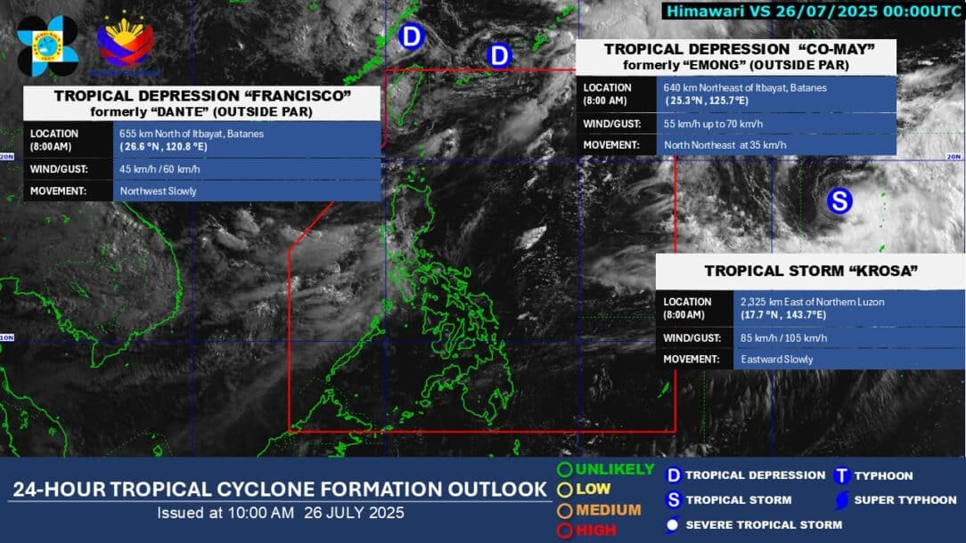
The state weather bureau said Emong left the PAR at 7:10 a.m., after it weakened into a tropical depression with maximum sustained winds of 55 kilometers per hour (km/h) and gustiness of up to 70 km/h.
“Sa kasalukuyan, wala na pong epekto si Bagyong Emong sa anumang bahagi ng ating bansa,” PAGASA Weather Specialist Grace Castañeda said.
PAGASA continuously monitors Emong and Tropical Storm Dante (international name: Francisco) outside the PAR.
The bureau also monitors Tropical Storm Krosa, which remains outside the PAR. As of 8 a.m., Krosa is located 2,325 kilometers east of Northern Luzon with maximum sustained winds of 85 km/h and gustiness of up to 105 km/h.
“Gaya po ni Bagyong Emong and ni Bagyong Dante, wala po itong epekto sa anumang bahagi ng ating bansa, and less likely rin po na pumasok ito sa loob ng ating area of responsibility,” Castañeda stressed.
However, she said that Krosa might “slightly enhance” the southwest monsoon, or habagat, in the coming days.
“‘Yung habagat po ‘yung patuloy na magdudulot ng mga pag-ulan ngayon, maging sa mga susunod na araw, lalong-lalo po sa may western section ng Luzon,” she said.
Rainfall forecast
While Emong left the PAR, PAGASA forecasted the southwest monsoon would continue to bring 50 to 100 millimeters of rain (moderate to heavy rains) over the following areas and days:
Saturday, July 26:
- Ilocos Norte
- Ilocos Sur
- La Union
- Pangasinan
- Zambales
- Bataan
- Occidental Mindoro
Sunday, July 27:
- Zambales
- Bataan
Monday, July 28:
- Ilocos Sur
- La Union
- Pangasinan
- Zambales
- Bataan
“Muli po, pag-iingat pa rin para sa ating mga kababayan sa banta ng mga pagbaha at pagguho ng lupa,” Castañeda advised.
Rains expected on SONA day
On Monday, President Ferdinand “Bongbong” Marcos Jr. will deliver his fourth State of the Nation Address (SONA) at the Batasang Pambansa Complex in Quezon City.
In its special weather outlook, PAGASA said the southwest monsoon is expected to bring mostly cloudy skies with chances of isolated rains or thunderstorms on Monday over the following areas:
- Metro Manila
- Ilocos Region
- Cordillera Administrative Region (CAR)
- Western Visayas
- Negros Island Region
- Zambales
- Bataan
- Cavite
- Batangas
- Occidental Mindoro
- Palawan
Meanwhile, the rest of the country may experience partly cloudy to cloudy skies with isolated rain showers or thunderstorms.
The Philippines is still dealing with the impact of Severe Tropical Storm Crising, Dante, Emong, and the southwest monsoon, which displaced thousands of Filipino families due to floods and put several areas in the country under a state of calamity.
The House of Representatives scrapped red carpet ceremonies, fashion coverage, or photo setups for Marcos’s SONA to show “solidarity” with typhoon-hit communities.