
JUST a week after severe tropical storm Kristine, the country is hammered again by Typhoon Leon, which continues to intensify as it sweeps west northwestward across the Philippine Sea on Wednesday.
According to PAGASA’s most recent Tropical Cyclone Bulletin, Wind Signal No. 4 is the highest that can be hoisted, particularly around the Batanes and Babuyan Islands. However, Wind Signal No. 5 is not ruled out.
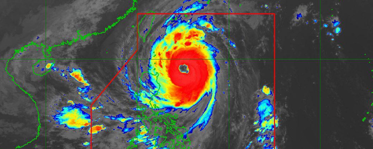
Leon is heading west-northwest at 15 kph and is expected to be at or near super typhoon status when it approaches Batanes. Landfall in Batanes is not ruled out.
Furthermore, the wind flow near the Leon will produce windy conditions ranging from strong to gale-force across various locations, especially in coastal and upland areas exposed to winds outside Wind Signal areas:
• Today (30 October): Bataan, Metro Manila, CALABARZON, MIMAROPA, Bicol Region, most of Visayas, and Dinagat Islands.
• Tomorrow (31 October): Aurora, Batangas, Quezon, MIMAROPA, and Bicol Region.
• Friday (1 November): Batanes, Cagayan, Isabela, and Aurora.
There is also a moderate to high risk of a life-threatening storm surge reaching 2.0 to 3.0 m above normal tide levels in the next 48 hours across low-lying or exposed coastal areas in Batanes and Cagayan.
Signal Numbers
Meanwhile, Tropical Cyclone Wind Signal (TCWS) Number 3 is activated in Batanes and the eastern half of the Babuyan Islands. Residents are encouraged to seek shelter in solid buildings, leave low-lying regions, and avoid the beaches and riverbanks.
Signal No. 2 is activated in the remaining areas of the Babuyan Islands, Cagayan, northern and eastern Isabela, Apayao, Kalinga, northern and eastern Abra, and Ilocos Norte.
Signal No. 1 covers the remaining parts of Isabela, Quirino, Nueva Vizcaya, Mountain Province, Ifugao, Benguet, Abra, Ilocos Sur, La Union, Pangasinan, Nueva Ecija, Aurora, and the northwestern region of Tarlac.
In addition, the northern portion of Bulacan, the northern portion of Quezon (including the Polillo Islands), Camarines Norte, the northern portion of Camarines Sur, and the northern and eastern portions of Catanduanes.
Tracking the Typhoon
Typhoon Leon is expected to travel northwest across the Philippine Sea before making impact on Taiwan’s eastern shore tomorrow afternoon, October 31.
After crossing Taiwan’s landmass, Leon will proceed north northwest to northeast across the Taiwan Strait towards the East China Sea, exiting the Philippine Area of Responsibility tomorrow evening or early Friday morning.
A second landfall over mainland China has not been ruled out over this time. The typhoon will be closest to Batanes tomorrow morning till noon. A landfall at Batanes is also not being ruled out.
It is also expected to continue rapidly increasing over the Philippine Sea until it makes landfall over Taiwan. Leon will most certainly be a super typhoon when it gets close to Batanes.
How useful was this post?
Click on a star to rate it!
Average rating 0 / 5. Vote count: 0
No votes so far! Be the first to rate this post.
We are sorry that this post was not useful for you!
Let us improve this post!
Tell us how we can improve this post?