AS TYPHOON Marce continues to move across the sea west of Ilocos Norte, the state weather bureau PAGASA reports that it is gradually diminishing, but another low pressure area (LPA) is being observed.
According to the most recent PAGASA Tropical Cyclone Bulletin, on Friday, November 8, the typhoon was sighted over 100 km west northwest of Laoag City, Ilocos Norte.

Photo Courtesy: PAGASA
Now that Marce PH continues to weaken, Tropical Cyclone Wind Signal (TCWS) No. 3 has been lifted already. However, local winds may still be slightly stronger in wind-prone coastal and upland/mountainous regions.
According to the state weather agency, the northeasterly wind flow and Marce’s periphery will also deliver strong to gale-force gusts across wind-prone coastal and upland locations:
• Today (8 November): Batanes, northern Cagayan including Babuyan Islands, and Ilocos Region.
Wind Signal Numbers
Despite weakening, TCWS No. 2 remains active in the northwestern portion of mainland Cagayan, the western portion of Apayao, Abra, Ilocos Norte, and the northern portion of llocos Sur.
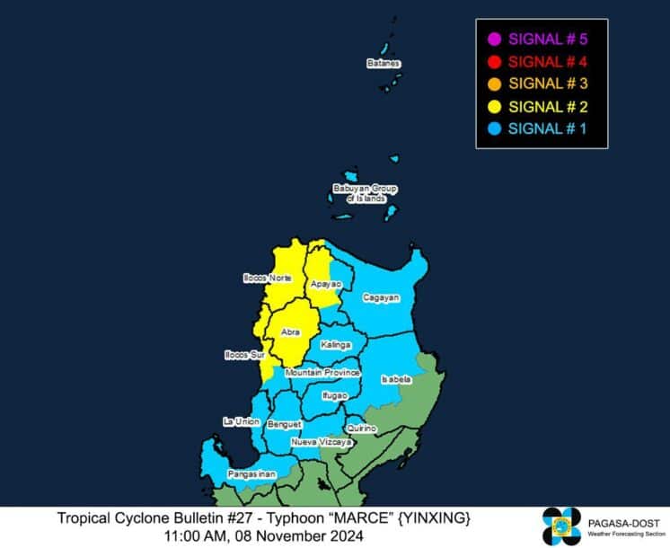
Photo Courtesy: PAGASA
Meanwhile, Signal No. 1 covers Batanes, Babuyan Islands, the rest of mainland Cagayan, the northern and western portions of Isabela, the northern and western portions of Nueva Vizcaya.
Along with them are the northwestern portion of Quirino, the rest of Apayao, Kalinga, Mountain Province, Ifugao, Benguet, the rest of Ilocos Sur, La Union, and the northern and central portions of Pangasinan
Latest update
Meanwhile, according to PAGASA’s anticipated track, Marce would continue to move westward until exiting the Philippine Area of Responsibility (PAR) this afternoon or evening.
Marce is expected to weaken in the following days due to likely dry air incursion from the prevailing northeasterly wind flow. Nonetheless, it will remain a typhoon during its passage across the PAR.
However, at 2:00 AM on Friday, a cloud cluster east of the country formed an LPA. It may enter the PAR on Friday evening or Saturday morning, but it has a low chance of becoming a tropical depression within the next 24 hours.