
KRISTINE has gone from a tropical depression to a tropical storm while keeping its intensity. If it maintains its strength, Signal No. 4 remains the highest Wind Signal to be hoisted, given the likelihood of rapid intensification.
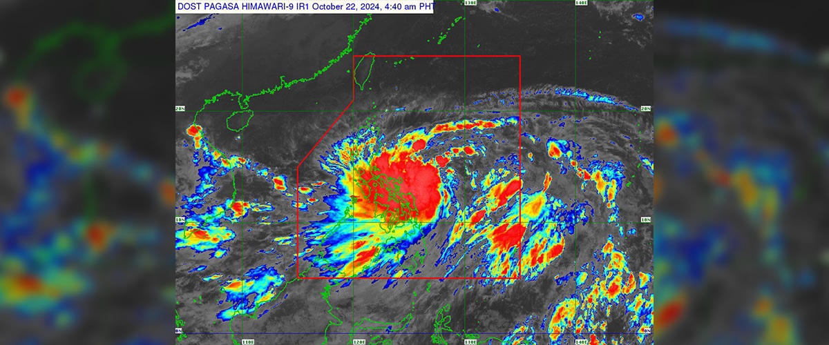
Based on the latest 5:00 AM Tropical Cyclone Bulletin of PAGASA, the “eye” or the center of Tropical Storm Kristine was estimated based on all available data at 390 km around East of Virac, Catanduanes.
Furthermore, the wind flow approaching the circulation of Kristine and the Northeasterly Windflow comes with strong to gale-force gusts within the following areas, especially in coast and highlands vulnerable to winds:
- Today (22 October): Batanes, Babuyan Islands, Ilocos Region, Palawan, Romblon, Aklan, Antique, Negros Island Region, Central Visayas, Southern Leyte, Zamboanga del Norte, Northern Mindanao, Dinagat Islands, Surigao del Norte, Agusan del Norte, Sarangani, Davao del Sur, and Davao Oriental.
- Tomorrow (23 October): MIMAROPA, Visayas, and Mindanao.
- Thursday (24 October): MIMAROPA, Bicol Region, Visayas, Basilan, Sulu, Tawi-Tawi, Zamboanga del Norte, Lanao del Sur, Northern Mindanao, Dinagat Islands, Surigao del Norte, Davao del Sur, and Davao Oriental.
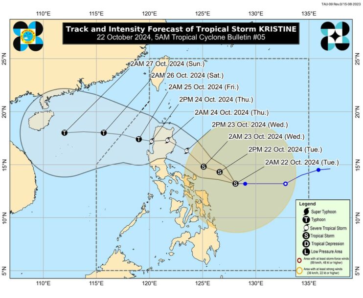
Photo Courtesy: PAGASA
Meanwhile, Kristine is expected to stay a tropical storm during the next 24 hours. It may reach the category of severe tropical storm tomorrow and make landfall as such over Isabela.
Wind Signal Numbers
According to PAGASA’s 11:00 AM Tropical Cyclone Bulletin, the Tropical Cyclone Wind Signal (TCWS) No. 2 has already been issued in Catanduanes.
In Luzon, TCWS No. 1 covers Metro Manila, along with several provinces such as Ilocos Norte, Ilocos Sur, La Union, Pangasinan, Apayao, Kalinga, Abra, Mountain Province, Ifugao, Benguet, Cagayan including Babuyan Islands.
Also under the said TCWS are Isabela, Quirino, Nueva Vizcaya, Aurora, Nueva Ecija, Tarlac, Zambales, Bataan, Pampanga, Bulacan, Cavite, Laguna, Batangas, Rizal, Quezon including Pollilo Islands, Masbate including Ticao Island, Burias Island, Marinduque, Romblon, and, Camarines Norte, Camarines Sur, Albay, Sorsogon
In Visayas, Eastern Samar, Northern Samar, Samar, Leyte, Biliran, and Southern Leyte. In Mindanao, Dinagat Islands and Surigao del Norte including Siargao – Bucas Grande Group are all under the said TCWS.
Current situation
Some netizens took to social media to report their current situation as a result of Tropical Storm Kristine. Despite the fact that TCWS No. 1 is the only signal now raised, they are experiencing a strong one.
In particular, a netizen from Bombon, Camarines Sur, shared footage on the X (Formerly Twitter) account depicting a rapidly running river, gusting winds, and heavy rainfall outside their house.
In Northern Samar, a netizen posted several images outside Sitio Inilian, Brgy. Balud and Brgy. Pagsangan, where they are already experiencing flooding as a result of the incessant rain.
Kristine is also forecast to intensify into a typhoon by Friday when it reaches the West Philippine Sea. Rapid intensification is still possible while the tropical cyclone remains over the Philippine Sea.
PAGASA has already encouraged the public and disaster officials to take all necessary precautions to preserve life and property as the tropical storm intensifies and moves over the country.