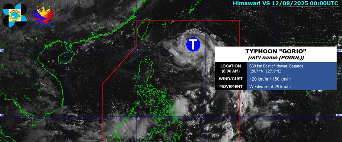

GORIO (international name: Podul) has now intensified into a typhoon but won’t directly impact the country’s weather, PAGASA said on Thursday.
As of 8 AM, the agency reported that Gorio is still being monitored within the Philippine Area of Responsibility (PAR).
They reported sustained winds near the storm’s center at 120 kilometers per hour, with gusts reaching up to 150 kilometers per hour, classifying Gorio as a typhoon.
It is currently located 630 kilometers east of Itbayat, Batanes, at coordinates 20.7°N, 127.9°E.
The typhoon is moving westward at a speed of 25 kilometers per hour, toward areas near Taiwan or the Bashi Channel, not making landfall in the Philippines.
Although it remains distant from Philippine Landmass, PAGASA still warns of possible tropical cyclone winds in Northern Luzon, especially if the typhoon would incline Southward.
The agency also warned residents near coastal areas to be cautious, as rough sea conditions and high waves are expected today. Sea travel is not advisable.
Gorio is expected to leave PAR on Wednesday evening.
It is the seventh tropical cyclone of 2025 and the second this August, following Tropical Depression Fabian.
PAGASA had forecasted two to three cyclones to enter or form within the PAR this month and said August could be the wettest month of the year.
How useful was this post?
Click on a star to rate it!
Average rating 0 / 5. Vote count: 0
No votes so far! Be the first to rate this post.
We are sorry that this post was not useful for you!
Let us improve this post!
Tell us how we can improve this post?