WITH the threat of Typhoon “Enteng,” classes have been suspended in advance for Monday, September 2, 2024.
According to an advisory from the Local Government Unit of Naga City in Camarines Sur, Sorsogon City, Camarines Sur and Northern Samar, has suspended classes in all levels both public and private.
Meanwhile, state weather forecasters raised Tropical Cyclone Wind Signal No. 1 in 11 areas on Sunday due to the Tropical Depression.
Under TCWS No. 1 are: the eastern portion of Camarines Sur (Presentacion, Garchitorena, Caramoan, Calabanga, Naga City, Pili, Bombon, Magarao, Ocampo, Baao, Nabua, Bula, Balatan, Bato, Milaor, Minalabac, Camaligan, Saglay, Iriga City, Buhi, Tigaon, San Jose, Goa, Siruma, Tinambac, Lagonoy, Canaman, Gainza, San Fernando); Catanduanes; Albay; Sorsogon; Burias Island; Ticao Island; Northern Samar; Samar; Eastern Samar; Biliran; and the northeastern portion of Leyte (Babatngon, San Miguel, Tacloban City, Alangalang, Santa Fe, Palo, Barugo).
According to PAGASA, the said areas will have strong winds ranging from 39 to 61 km/h in 36 hours.
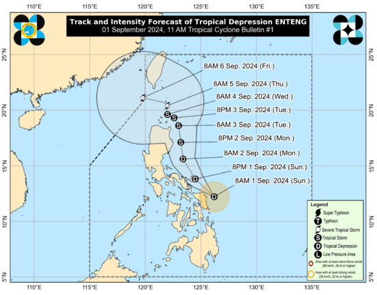
As of the 10 a.m. forecast, the center of Enteng was estimated to be located at 120 km North Northeast of Borongan City, Eastern Samar or 150 km East of Catarman, Northern Samar (12.6°N, 126.0°E).
Enteng has maximum sustained winds of 45 km/h near the center, gustiness of up to 55 km/h, and central pressure of 1002 hPa.
The tropical depression is moving northwestward at 30 km/h.
From Enteng’s center, strong winds are extending outwards up to 150 km.
From Monday noon to Tuesday noon on the other hand, the forecast accumulated rainfall is 100 to 200 mm for Isabela, and 50 to 100 mm for Cagayan, Quirino, Apayao, Kalinga, Mountain Province, Ifugao, Abra, Ilocos Norte, and Ilocos Sur.
Meanwhile, the Southwest Monsoon (Habagat) is expected to bring moderate to intense rainfall in parts of Luzon and Visayas, particularly along the western portions.
Enteng is expected to move generally northwestward to north northwestward on Sunday.
On Monday, it will turn more northward as it gradually intensifies.
It added that Enteng may become a tropical storm on Monday, then a severe tropical storm by Thursday.
Keep monitoring republicasiamedia for the latest on class suspensions and the weather.
How useful was this post?
Click on a star to rate it!
Average rating 0 / 5. Vote count: 0
No votes so far! Be the first to rate this post.
We are sorry that this post was not useful for you!
Let us improve this post!
Tell us how we can improve this post?


