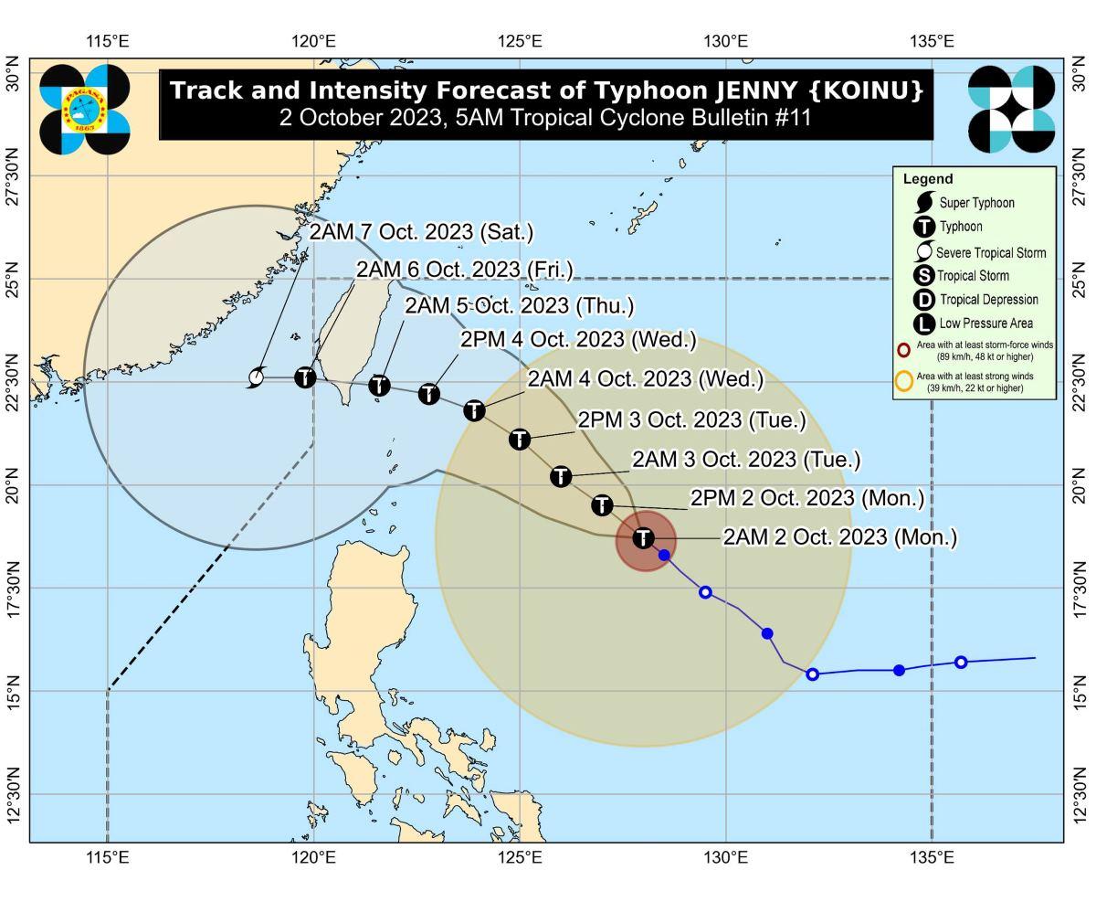

SEVERE Tropical Storm Jenny with an international name of Koinu further intensified and is now a typhoon as it continues to traverse the Philippine Sea.
According to the latest PAGASA bulletin they hoisted Tropical Cyclone Wind Signal (TCWS) No. 1 in: Batanes; Babuyan Islands; the eastern portion of mainland Cagayan (Santa Ana, Gonzaga, Buguey, Santa Teresita, Lal-Lo, Baggao, Gattaran, Peñablanca); and the eastern portion of Isabela (Maconacon, Divilacan, Palanan).
The said areas are expected to have strong winds for the next 36 hours.
The winds are expected at 39 to 61 km/h, with minimal to minor threat to life and property.
The center of the Typhoon Jenny was last estimated at 655 km east of Aparri, Cagayan or 665 km east of Calayan, Cagayan.
It carries a maximum sustained winds of 120 km/h near the center, and gustiness of up to 150 km/h.
It is moving ]northwestward at 10 km/h.
Meanwhile, Batanes, Babuyan Islands, and the northern portion of mainland Cagayan is expected to experience 50-100 mm of rainfall come Tuesday.
By Wednesday, Batanes will have 100-200 mm rainfall, while Babuyan Islands, Ilocos Norte, and the northern portions of mainland Cagayan and Apayao may have 50 to 100 mm of rainfall.
“Under these conditions, flooding and rain-induced landslides are possible especially in areas that are highly or very highly susceptible to these hazards as identified in hazard maps and in localities that experienced considerable amounts of rainfall for the past several days,” PAGASA said.
The typhoon is expected to enhance the Southwest Monsoon (Habagat).
How useful was this post?
Click on a star to rate it!
Average rating 0 / 5. Vote count: 0
No votes so far! Be the first to rate this post.
We are sorry that this post was not useful for you!
Let us improve this post!
Tell us how we can improve this post?