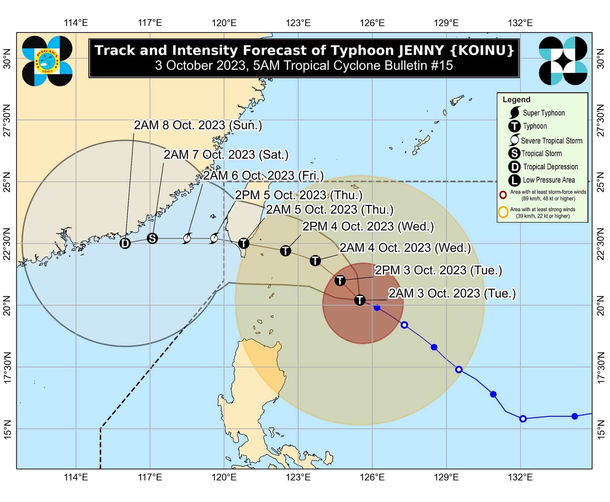

TYPHOON Jenny maintained its strength while over the Philippine Sea, according to the state weather bureau PAGASA on Tuesday morning.
At 4 a.m., the center of Jenny was located 350 kilometers east of Basco, Batanes, carrying maximum sustained winds of 165 kilometers per hour and gustiness of up to 205 km/h.
It was moving west northwestward at 15 km/h.
Tropical Cyclone Wind Signal Number 2 was raised over Batanes while Signal No. 1 is in effect in the following areas:
Cagayan including Babuyan Islands
the northern and eastern portions of Isabela (Maconacon, Divilacan, Palanan, Santa Maria, San Pablo, Tumauini, Cabagan, Ilagan City, San Mariano, Santo Tomas, Dinapigue, Benito Soliven, Naguilian, Gamu, Quirino, Delfin Albano, Quezon, Mallig)
Apayao
the northeastern portion of Abra (Tineg, Lacub, Malibcong)
the northern portion of Kalinga (Balbalan, Pinukpuk, Rizal, City of Tabuk), and Ilocos Norte
The enhanced Southwest Monsoon (Habagat) will bring occasional rains over the western portions of Central Luzon, Southern Luzon, and Visayas in the next three days.
Jenny is forecast to make landfall over the southern portion of Taiwan between late Wednesday evening or Thursday morning then exit the Philippine Area of Responsibility between Thursday morning and afternoon.
“Jenny is likely at or near its peak intensity. A weakening trend is forecast to begin today due to increasing dry air entrainment and vertical wind shear,” PAGASA said in its 5 a.m. bulletin.
“Land interaction during its passage over the rugged terrain of southern Taiwan will further weaken the tropical cyclone. Once over the Taiwan Strait, additional cool dry air from the north will entrain into Jenny, resulting in continued weakening.”
How useful was this post?
Click on a star to rate it!
Average rating 0 / 5. Vote count: 0
No votes so far! Be the first to rate this post.
We are sorry that this post was not useful for you!
Let us improve this post!
Tell us how we can improve this post?