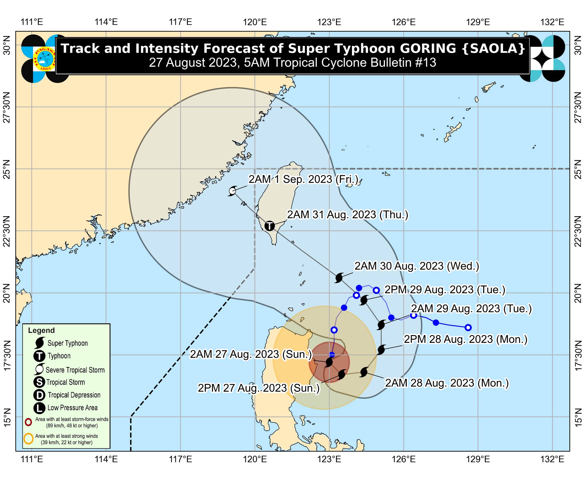

Several areas in Luzon were placed under storm warnings as Goring turned into a super typhoon early Sunday morning, PAGASA said.
Carrying maximum sustained winds of 185 kilometers per hour near the center and gustiness of up to 230 km/h, Goring was spotted over the coastal waters of Palanan, Isabela, at 4 a.m.
It was moving south southwestward slowly.
Signal No. 3 was raised over the extreme eastern portion of Isabela (Divilacan, Palanan), while Signal No. 2 was hoisted over the following areas:
- the eastern portion of mainland Cagayan (Peñablanca, Baggao, Gattaran, Lal-Lo, Gonzaga, Santa Teresita, Buguey, Santa Ana)
- the eastern portion of Isabela (Dinapigue, Ilagan City, Maconacon, Cabagan, Tumauini, San Pablo, Benito Soliven, San Mariano)
- the extreme northern portion of Aurora (Dilasag, Casiguran)
Under Signal No. 1 are the following areas:
- Babuyan Islands
- the rest of mainland Cagayan, the rest of Isabela, Quirino, Nueva Vizcaya, Apayao, Kalinga, Abra, Mountain Province, Ifugao
- the eastern portion of Benguet (Bokod, Buguias, Kabayan, Mankayan)
- the eastern portion of Ilocos Norte (Pagudpud, Adams, Vintar, Carasi, Nueva Era, Banna, Marcos, Dingras, Solsona, Piddig, Dumalneg, Bangui)
- the northeastern portion of Nueva Ecija (Carranglan, Pantabangan, Bongabon, Gabaldon, Laur, Rizal)
- the northern and central portions of Aurora (Dinalungan, Dipaculao, Baler, Maria Aurora, San Luis)
- Polillo Islands
- Calaguas Islands
Meanwhile, the Southwest Monsoon enhanced by Goring will bring occasional or monsoon rains over the western portions of Central Luzon, Southern Luzon, and Visayas over the next three days.
Goring is expected to begin its loop over the Philippine Sea east of the Cagayan-Isabela area on Sunday, PAGASA said.
”The super typhoon will then turn northeastward and northward on Monday before shifting to a more northwestward movement on Tuesday. On the track forecast, Goring will make landfall over the southern portion of Taiwan on Wednesday evening or on Thursday early morning,” it added.
Goring is forecast to remain a super typhoon until it makes landfall over southern Taiwan.
”Land interaction with Taiwan’s rugged terrain will weaken the super typhoon. It is likely that Goring will emerge over the Taiwan Strait and exit the PAR (Philippine Area of Responsibility) region as a severe tropical storm or a minimal typhoon,” PAGASA said.
How useful was this post?
Click on a star to rate it!
Average rating 0 / 5. Vote count: 0
No votes so far! Be the first to rate this post.
We are sorry that this post was not useful for you!
Let us improve this post!
Tell us how we can improve this post?