VISAYAS and Mindanao are getting the reprieve after almost one month of intermittent rains brought by the Low Pressure Area and Shear Line.
There will still be rains alright, but not as heavy as the past weeks, state weather forecasting agency Pagasa said Tuesday.
Pagasa hydrologists also took down all the general flood warning advisories in Eastern Visayas.
Bicol, Quezon rains from LPA
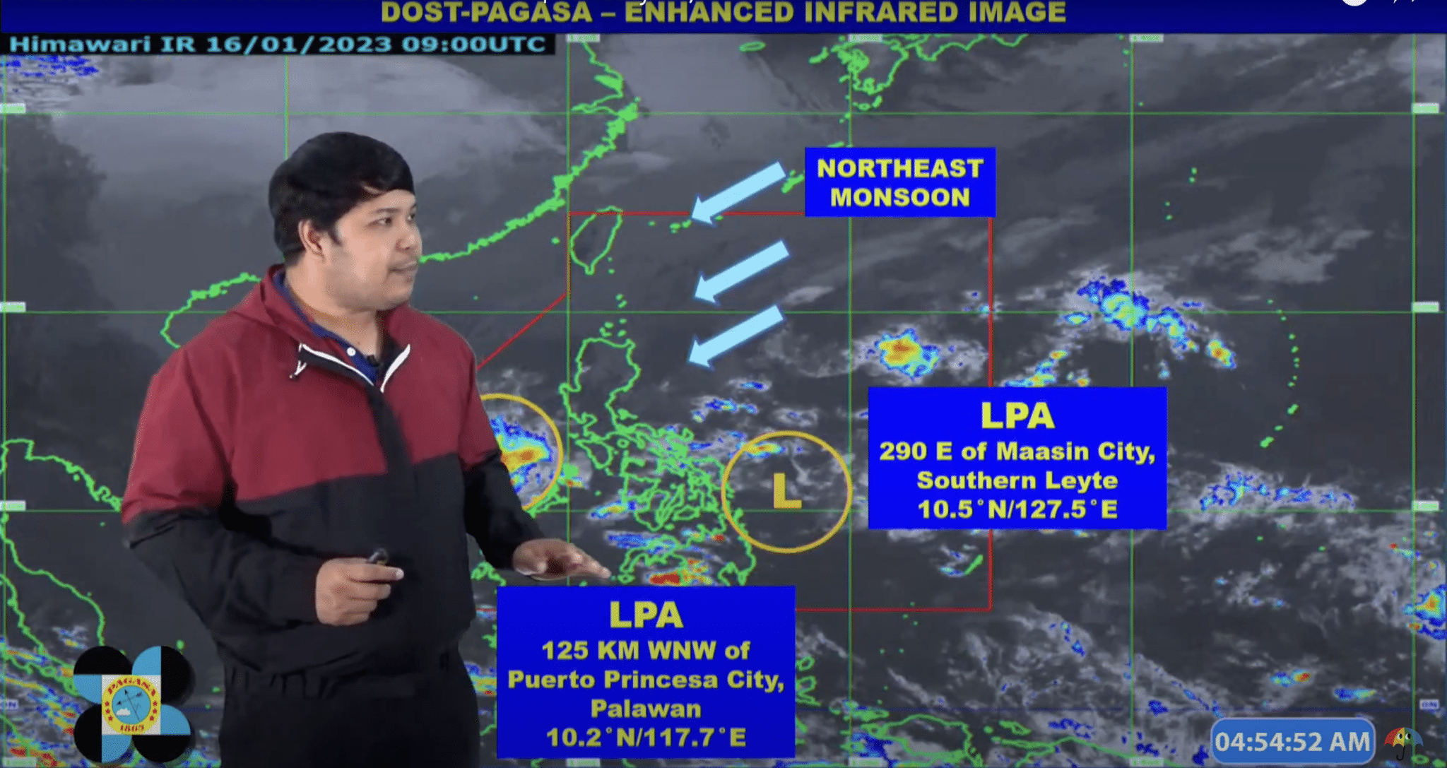
As of 3am, January 17, Pagasa said the LPA east of Visayas is located around 290 kilometers east of Maasin City in Southern Leyte.
Meteorologists forecast the LPA will dissipate today or tomorrow.
Although this LPA is weakening, its trough will bring light to moderate with at times heavy rains over Bicol Region and Quezon. Another weather system — the Shearline — is also bringing rain clouds over this side of the northeastern corridor.
Pagasa raised a severe general flooding alert over the Bicol Region.
Meanwhile, another LPA formed around 125 km west northwest of Puerto Princesa City in Palawan.
Palawan and Occidental Mindoro will have scattered rain showers and thunderstorms due to LPA and Shearline.
Batanes, Apayao, Cagayan rains from amihan
The Northeast Monsoon is still the prevailing weather system in most provinces of Luzon.
Batanes, Apayao and Cagayan will get moderate to heavy rains today. So watch out for flooding or rain-induced rains.
Isabela, Quirino, Nueva Vizcaya, Ilocos Norte, Ilocos Sur, La Union, Pangasinan, Abra, Benguet, Mountain Province, Ifugao, Kalinga and Aurora will have partly to cloudy skies and occasional light rains.
Rest of the country
It’s generally fair weather for the rest of the country — partly cloudy to cloudy skies with isolated rain showers or thunderstorms.
The rains will be light, if at all.
Temperature check
Coolest temp
It got a bit warmer yesterday in Baguio City at 16.2°C, but still coldest temperature recorded in the country yesterday by Pagasa. The coldest wind brought by the Northeast Monsoon blew around 7:15 am yesterday. For today, Pagasa expected the same range of 16°C as coldest to 23°C.
Basco, Batanes was just a bit warmer than Baguio at 18.5°.
Tanay, Rizal, Aparri in Cagayan and Malaybalay, Bukidnon registered 20°C level around 6 am or 7 am.
Calayan in Cagayan, Baler in Aurora, Sinait in Ilocos Sur, Tuguegarao City in Cagayan and Abucay, Bataan also dropped to 21°C level yesterday.
HOTTEST TEMP
Davao City had 33°C, the hottest temperature recorded yesterday around 3pm.
Zamboanga, Catbalogan, and Dagupan cities had 32°C level around 2pm yesterday.
Dipolog, Butuan, Malaybalay in Bukidnon, Borongan and Legazpi Cities, and Dauis in Bohol all suffered 31°C around 12 noon yesterday.
Forecast temperature today
- Baguio: 16-23°C
- Tuguegarao: 22-29°C
- Laoag: 23-29°C
- Metro Manila: 24-31°C
- Tagaytay: 23-29°C
- Legazpi: 24-30°C
- Kalayaan Islands: 25-30°C
- Puerto Princesa: 24-29°C
- Cebu: 25-30°C
- Iloilo: 25-30°C
- Tacloban: 24-31°C
- Cagayan de Oro: 25-30°C
- Davao: 26-33°C
- Zamboanga City : 35-32°C
Weather at a glance
| Place | Weather Condition | Caused By | Impacts |
|---|---|---|---|
| Bicol Region and Quezon | Cloudy skies with scattered rainshowers and thunderstorms | LPA / Shear Line | Possible flooding or landslides due to moderate to heavy rains |
| Batanes, Cagayan, and Apayao | Cloudy skies with rains | Northeast Monsoon | Possible flooding or landslides due to moderate to heavy rains |
| Metro Manila and the rest of Luzon | Partly cloudy to cloudy skies with light rains | Northeast Monsoon | No Significant impact |
| The rest of the country | Partly cloudy to cloudy skies with isolated rainshowers or thunderstorms | LPA / Localized Thunderstorms | Possible flash floods or landslides during severe thunderstorms |