GET ready for rain or drizzles when you head out to visit family and loved ones during the holidays.
Many parts of the country will have cloudy skies with some rain for Christmas and New Year, according to the special weather forecast for the holidays issued by the state weather bureau.
The northeast monsoon, the passage of a low-pressure area, and the southward movement of the shear line, or the convergence of northeasterly and easterly winds that forms rain clouds, are the weather systems that will likely affect most parts of the country during the holidays, the Philippine Atmospheric, Geophysical, and Astronomical Services Administration said.
Christmas weather From December 22 to 28, there will be cloudy skies with rain showers and thunderstorms over Southern Luzon, Visayas, and the Caraga region. These will become frequent rains over Eastern Visayas, Surigao del Norte, Dinagat Island, and the Bicol Region by December 26 and 27.
Metro Manila and the rest of Luzon will have partly cloudy to cloudy skies with light rains. The rest of the country will be partly cloudy to cloudy with isolated rain showers or thunderstorms.
On December 29, Southern Luzon and the Visayas will have cloudy skies with rain showers and thunderstorms. The rest of Luzon will have partly cloudy to cloudy skies with light rains. Mindanao will have partly cloudy to cloudy skies with isolated rain showers or thunderstorms
New Year weatherFrom December 30 to January 1, Cagayan Valley, Aurora, Quezon, and the Bicol Region will have cloudy skies with light rains.
Metro Manila and the rest of Luzon will have partly cloudy to cloudy skies with light rains. The rest of the country will experience partly cloudy to cloudy skies with isolated rain showers or thunderstorms.
Heading out to sea?
PAGASA said sea travelers should exercise extra caution as big waves are expected over the holidays, particularly over the seaboards of Luzon and the Visayas.
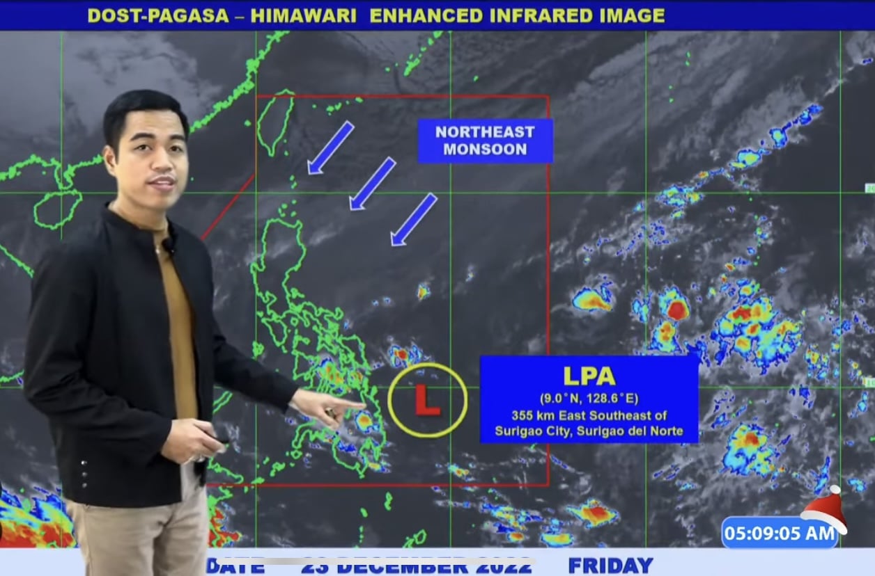
Low pressure area
The low pressure area that PAGASA has been monitoring is currently east of Surigao del Norte. It is not expected to develop into a tropical storm and could dissipate in the coming days, according to forecaster Benison Estareja.
In the meantime, it will bring rains in many areas in the Visayas and parts of Southern Luzon.
Today’s weather Luzon
Light to moderate rains are expected in Cagayan Valley, the Cordillera Administrative Region, Aurora, Quezon, Camarines Norte and Camarines Sur. Landslides and floods are possible.
The rest of the Bicol region and mainland Palawan will also have rains due to the extension of the low pressure area. There may be heavy rain and thunderstorms, and the public is advised to watch out for possible landslides and flash floods.
In the rest of Luzon, it will be cloudy with some light rains.
Visayas
People in the Visayas are advised to bring umbrellas when going out as thunderstorms and scattered rain showers are expected today, especially in Eastern Visayas, due to the low pressure area.
Mindanao
Mindanao will have localized thunderstorms, especially at noon and in the afternoon.
The most affected areas will be Zamboanga Peninsula, Northern Mindanao, and Caraga region.
Temperature check
The mercury is dropping, especially in Baguio where it is expected to go down to 13 degrees Celsius today.
Metro Manila’s temperature today will range from 30 to 23 degrees Celsius.
The temperature in Laoag will be from 30 to 21 degrees Celsius, and for Tuguegarao 27 to 19 degrees Celsius.
In Tagaytay it will be from 28 to 19 degrees Celsius.
In Legazpi, the temperature will be from 29 to 23 degrees Celsius, Puerto Princesa 29 to 24 degrees Celsius, and Kalayaan Islands 30 to 25 degrees Celsius.
Visayas will have lower temperatures as well. In Cebu it will be from 29 to 25 degrees Celsius, Tacloban 30 to 24 degrees Celsius, and Iloilo 30 to 25 degrees Celsius.
Mindanao will be warm. The temperature in Davao will range from 33 to 25 degrees Celsius, in Cagayan de Oro 31 to 24 degrees Celsius, and Zamboanga 33 to 24 degrees Celsius.
Gale warning
PAGASA has issued a gale warning over several areas in Luzon and the Visayas due to the strengthening of the northeast monsoon.
The waves could reach as high as 5.5 meters, equivalent to a two-storey building, in the following areas:
- Batanes
- Cagayan
- Ilocos Norte
- Ilocos Sur
- La Union
- Pangasinan
- Aurora
- Zambales
- Quezon
- Camarines Norte
- Camarines Sur
- Catanduanes
- Albay
- Sorsogon
- Masbate
- Romblon
- Marinduque
Waves could reach up to 4.5 meters in the following areas:
- Batangas
- Oriental Mindoro
- Occidental Mindoro
- Palawan
- Aklan
- Antique
- Capiz
- Northern Samar
- Eastern Samar
Small sea craft and fisherfolk are advised not to head out to sea. There is also a chance of sea travel suspensions.
Visayas forecast
Ang Kalayaan Islands, ug ang Occidental Mindoro makasinati ug panagsang mapanganuron ngadto na sa madag-umon na kalangitan nga naay mga hinay nga pag-ulan tungod sa Amihan. Ang Visayas ug nahibiling bahin sa Palawan makasinati ug madag-umon na kalangitan inubanan sa mga katag-katag na mga pag-ulan, pagpangilat ug pagpanugdog tungod sa LPA.
Kasarangan ngadto sa kusog na hangin nga gikan sa Amihanang-silangan ngadto na sa Amihanan ang mupasulabi sa Visayas, Palawan lakip na ang Kalayaan Islands, ug sa Occidental Mindoro diin ang kadagatan adunay kasarangan ngadto sa baluron ang kahimtang.
Mindanao forecast
Ang tibuok dapit sa Mindanao makasinati sa panalagsang pagdag um ngadto na sa mapanganuron nga kalangitan inubanan sa patak-patak nga pag ulan, kilat ug panalugdog tungod sa Localized Thunderstorms. Hinay ngadto na sa kasarangan nga hangin nga maga gikan sa amihanang silangan ngadto na sa amihanang kasadpang direksyon ug hapsay ngadto na sa kasarangan ang pagbalud sa kadagatan.